Don't you just hate it when you read an
important official notice to boaters which says “Un cerclage vert
repère
les arbres chancrés”
and you look up “cerclage” in your French–English
dictionary and it translates it as cerclage?
Mathilde briefly visited the Grand
Bassin of Castelnaudary, which had a very Mediterranean look, I
thought, before moving to another marina in the same town.
I walked up to the highest point of the town,
finding an old windmill. On this high point, a good place for viewing
battles, there was a helpful plaque described battles fought here: in
1211 (the Cathars lost) and 1632 (the revolting people of Languedoc
lost).
There was another helpful plaque about the
water supply from the Black Mountains to feed the Canal du Midi.
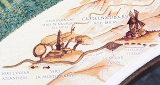
Castelnaudary is 180 metres above sea level; soon we should get to
the Seuil de Naurouze at the watershed, at 189 metres the highest
point of the Canal du Midi, from which you either go down towards the
Mediterranean or, in Mathilde's case, down towards the
Atlantic. So far this year we been through 103 locks (counting a
double lock as two). The last was quadruple, called for St-Roch, the
guy with the sore leg. The previous lock was called Gay.
The temperature during the day is pleasantly
warm—it was no pain to cycle a few hundred metres with a jerrycan
to get petrol—but the sun on Mathilde is strong, so she is
uncomfortably hot for much of the day. This is not a great problem,
as there are other places, like this internet café,
to lurk. And Castelnaudary has several pleasant squares.
I have booked a few more nights here,
planning a visit to a market in a neighbouring village tomorrow
(Saturday). Rain is promised on Sunday, which may make housekeeping
in Mathilde comfortable. Monday is market day in
Castelnaudary; I will leave for Toulouse around the middle of the
day.


No comments:
Post a Comment